This
write-up is about a 1970 motorcycle road trip Jean and I made across
the width of Florida, coast to coast, from the Atlantic Ocean to the
Gulf of Mexico, I’m writing this in 2022 and don't recall many details
but will do the best I can based on the few photos we took.
Background:
Jean
and I were married in August of 1969 and had bought a new house 8
months later. This motorcycle trip was about one year after we were
married and two months after we moved into our house. This ride was a
3-day, 350-mile round trip to Sanibel Island. Jean rode her 1967 Honda
Super 90 (90cc) that she bought second-hand in 1968 when she was still
single, and I rode my 1965 Yamaha 250 Big Bear Scrambler (250 cc) that I
bought in 1965.
Jean’s
Honda S90 bike was one of Honda’s early success models. It was
lightweight (175 pounds wet) due to its pressed steel frame to save
weight over tubular construction of other similar bikes. Its 8-hp
engine would allow a top speed of 60+ miles per hour, plus the bike was
extremely reliable. Jean had been riding her S90 for about 2 years but
this would be her first "long-distance" ride. The S90 was more than
adequate for this trip as we would not be on any high-traffic,
high-speed highways.
I had been riding motorcycles for about 5
years but this would also be my first “long-distance" road trip, most of
my riding had been off-road. I had previously installed a large rear
sprocket on my bike for trail riding and enduros, but even with this
sprocket and off-road tires my top speed was also more than adequate for
this trip.
I don’t remember what prompted Jean and I to make a 3-day motorcycle ride, maybe the TV show “Then Came Bronson” was an influence?
Also I don’t remember exactly why we chose Sanibel Island as our destination but I think it had to do with Sanibel Island being famous for its beauty, its miles of pristine beaches, and having one of the best places in Florida to find seashells. Sanibel was considered the best shelling spot in North America according to Travel & Leisure Magazine. One source said “There are 400 seashell varieties in all, rolling onshore by the thousands every day. Horse conches, jingle shells, giant cockles, calico scallops—take your pick." Plus it was a “coast to coast” ride, which had a nice ring to it.
The following illustration shows the route Jean and I took on this 3-day trip to Sanibel Island.
 |
Above: Google map showing our route. |
Day 1: June 3, 1970 (Wednesday): Riding to Sanibel Island
Jean and I left from our house in Juno Isles on June 3, 1970, a beautiful sunny day. We rode north on Ellison Wilson Road to Donald Ross Road to A1A to the town of Jupiter where we picked up Indiantown Rd and followed that west all the way to SR 710 (aka Beeline Highway). On the Beeline highway we headed northwest until we reached the St. Lucie Canal at the Indiantown border.
Indiantown is where I used to skydive a few years earlier, in 1966 and early 1967, before I got more interested in riding motorcycles. Indiantown is also the home of fictional comic character Roscoe Sweeney from the strip “Buzz Sawyer.” Sweeney was one of my heroes when I was a kid.
At the Indiantown border we took SR 76 west all the way to Lake Okeechobee where the St. Lucie Canal flows into Lake Okeechobee, close to the small lakeside community of Port Mayaca.
Lake Okeechobee, also known as Florida's inland sea, is the largest lake in Florida, it’s so wide you cannot see the opposite shore, if you are crossing the lake in a boat it's 25 miles from one lock to the next lock. And I’ve read the lake is the third largest natural freshwater lake by area wholly within the US.
Lake Okeechobee is also touted as having some of the best freshwater fishing in America: bass fishing is popular here, as well as other types of fish.
An interesting fact to me about Lake Okeechobee is that it is part of the Okeechobee Waterway, a waterway that extends from the Atlantic Ocean to the Gulf of Mexico. The waterway runs through Lake Okeechobee and consists of the Caloosahatchee River to the west of the lake and the St. Lucie Canal east of the lake. The Okeechobee Waterway was created to provide a water route across Florida, allowing boats to pass east–west across the state rather than traveling the long route around the southern end of the state. Sort of Florida’s version of the Panama Canal you might say. So a boat can sail, paddle or motor from the Atlantic Ocean to the Gulf of Mexico through this waterway.
After Jean and I reached Lake Okeechobee we headed south on SR 98 and rode another 11 miles along the shore of the lake until we arrived at Canal Point, another small community lakeside. At Canal Point we stopped for our first break, and to admire the lakeside scenery. We had been riding a little over an hour and traveled about 50 miles at this time. We took a few photos which are shown below.
 |
Above: Jean at Lake Okeechobee. |
 |
| Above: Lowell at Lake Okeechobee. |
 |
| Above: Jean at Lake Okeechobee. |
Leaving Canal Point we continued south through Pahokee to Belle Glade and then headed west passing through a series of other small towns on the southern end of Lake Okeechobee; South Bay, Lake Harbor and Clewiston.
The
2 photos below were made somewhere among these small communities, but I
don't recall exactly where. I remember I lost the map I had and Jean
and I turned around to look for it. These photos were taken about that
time but I don't recall if they were taken before I lost the map or
perhaps after we found the map.
 |
Above: Lowell with a map. |
 |
| Above: Jean somewhere, looking for the map I believe. |
When we entered Clewiston we stopped at a gas station to top off our fuel tanks and check our chain adjustments. See photo below.
 |
| Above: Checking chain adjustment. |
The
restaurant in the background of the above photo was the Old South
Bar-B-Q Ranch, a Florida institution. Billboards across the state
invited diners to the restaurant in Clewiston. I didn't notice the
restaurant when we were there, I only noticed the name later when
looking at this photo after scanning the negative (the original prints
had the name cropped off). I now wish we had stopped there for a cold
drink.
The following map shows the small towns we rode through getting to Clewiston.
 |
Above: Map showing towns around Lake Okeechobee. |
The farms around the southern end of Lake Okeechobee grow a lot of sugarcane and each year the farmers burn the fields before the harvest and we would often see the smoke from where we lived on the eastern coast of Florida.
After
our stop at Clewiston we continued on US 80 for about 55 miles to SR 93
and then headed south to SR 876 where we headed west again to Punta
Rassa (suburban neighborhood to Fort Myers) where the Sanibel Island
Causeway starts. The total ride from Clewiston to the causeway was
about 80 miles.
The following map shows the area of Sanibel and Captiva Islands, and the causeway.
 |
| Above: Map showing the barrier islands of Sanbel and Captiva. |
The causeway from the mainland at Punta Rassa to Sanibel Island is about 3 miles long and consists of three separate two-lane bridge spans and two man-made islands between them. The causeway islands were dredged from the San Carlos Bay when the bridges were built. The three bridges are just referred to as A, B, and C. The two man made islands are referred to as A and B. The following Google map shows theses bridges and man made islands. (Note this is from a 2022 map but would have looked pretty much the same in 1970.)
 |
| Above: Map showing 3 bridges and 2 man made islands of the causeway. |
The causeway was a fun ride as it gave us a great view of the San Carlos Bay. The round trip toll for motorcycles was $2. We paid riding onto Sanibel Island but there was no charge for riding off Sanibel Island.
The Sanibel Causeway was just opened in 1963, 7 years before our motorcycle ride, replacing a ferryboat that had run from Punta Rassa to Sanibel since 1912. The bridge closest to Punta Rassa had a drawbridge the year we rode over it, but we were not lucky enough to see it in operation.
Sanibel is one of the few barrier islands with an east-west orientation: most barrier islands are north-south. Hence, the island has great sandy beaches that face due south and southwest for 17 miles along the Gulf of Mexico.
We
pulled off and stopped at one of the causeway island (the first one I
believe, but I'm not certain) and took the following photos. We rode
our bikes right up to the water's edge.


 |
| Above: All the above photos are from the man made causeway island where we stopped. |
After that stop we rode our motorcycles over to Sanibel Island but were too early to check into our motel, so we rode around for a while. We finally checked into our motel, the Jolly Roger Motel, where we had reservations to stay two nights, which was about a 5-mile ride after leaving the causeway. The Jolly Roger Motel was advertised as Sanibel Island’s newest and most modern motel, with the largest motel pool in southwest Florida, plus it was directly on the Gulf of Mexico with a very nice beach. Following are a photo of the Jolly Roger Motel where we stayed, and a newspaper ad for the motel.
 |
| Above: Front of the Jolly Roger Motel. |
 |
| Above: Ad for the Jolly Roger Motel. |
I
don’t recall where we had our meals on this trip, perhaps just at the
motel as we had an efficiency apartment with a kitchenette. I also
don’t recall what we did after we checked into our room, perhaps just
rested the rest of the day, had a few cocktails, and spent some time on
the beach.
Day 2: June 4, 1970 (Thursday): Touring Sanibel and Captiva Islands
On
this day we again hopped on our bikes and toured Sanibel and Captiva
Islands, stopping at several beaches to look for seashells. The
following illustration shows some seashells that can be found on the two
islands.
 |
| Above: Illustration showing seashells. |
The ride from the Jolly Roger Motel to the Blind Pass Bridge that separates Sanibel Island and Captiva is about 7 miles and we stopped there to view the two beaches there, Blind Pass Beach (Sanibel Island side) and Turner Beach (Captiva Island side). The following photos are from Turner Beach.
 |
| Above: Jean at Turner Beach. |
 |
| Above: Lowell at Turner Beach. |
Sanibel Island and Captiva originally were just one island but the 1926 Great Miami Hurricane created a new channel now known as Blind Pass, and created the two separate islands. The following photo (from the Internet) shows the two islands, Blind Pass, and the Blind Pass Bridge that connect the islands.
 |
| Above: Photo from the Internet showing the Blind Pass Bridge. |
After we crossed the Blind Pass Bridge we continued on north to the end of Captiva Island where we stopped at another beach to look for seashells. There's a name for the bent-over position people get when they search for seashells, it's called the "Sanibel Stoop" or "Captiva Stoop" depending which island you are on. The following photos are from after we left the Blind Pass Bridge.
 |
| Above: Jean checking her shelling map for beach locations. |
 |
| Above: Lowell & Jean at a beach on Captiva Island. |
 |
 |
Above 2 photos: Jean doing the "Captiva Stoop" looking for seashells. |
 |
| Above: Lowell & Jean at a Captiva beach. |
After the last Captiva Island beach stop we headed back south toward Sanibel Island. See the following photo.
 |
Above: Jean riding back from Captiva heading for Sanibel Island. |
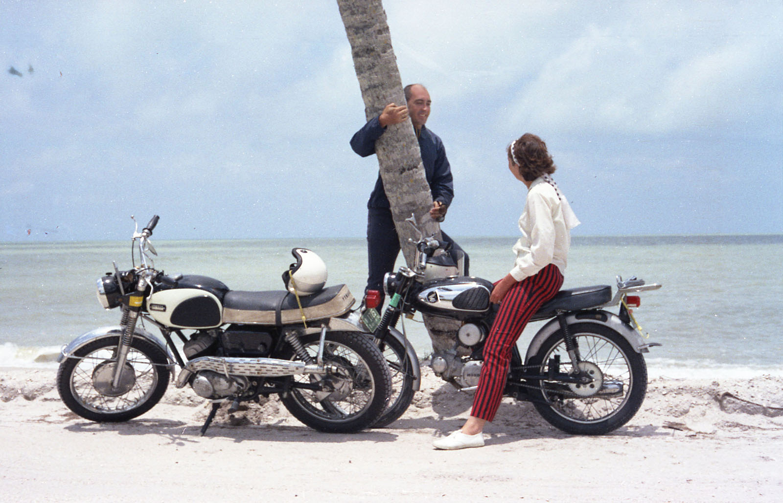
Once we were back on Sanibel Island we stopped at the Castaway Restaurant for a cold beer and just to look around. Close by was a marina on Sunset Bay where they rented boats. The following photos are from that stop.
 |
Above: Jean at the Castaways Restaurant. |
 |
Above: Jean at Sunset Bay. |
 |
Above: Lowell at the Castaway Marina. |
 |
Above: Jean posing with a tree. |
Once back at the Jolly Roger Motel we spent some more time on their beach, including looking for seashells. The following photos are from the Jolly Roger Motel beach.
 |
Above: Jean on the beach back at the Jolly Roger Motel. |
 |
Above: Made by Lowell |
Day 3: June 5, 1970 (Friday): Heading Home:
On the ride back from Sanibel, we had gone about 60 miles and I started experiencing an engine problem where I would just lose power and the engine would eventually die. This happened on and off for about 20 miles, I stopped many times to check points, plugs, gas filter, etc. but never identified the problem; but the engine would always eventually restart and run a little more.
When we finally got to some civilization (Clewiston), I made a decision to end our motorcycle ride there because we were lucky enough to find a gas station that also rented trucks (they just had one truck). We loaded up the two bikes in the rental truck and continued on home that way. That was part of our experience I guess, another memory. The map below shows approximately where my bike started giving me the problem.
 |
Above: Map showing motorcycle problem area. |
My main worry was getting stuck out in the boonies with only one bike and no place to stay once it got dark. Back then there wasn't much between Fort Myers on the west coast and the Palm Beach area on the east coast, just a long lonely road.
The following photo is of the Yamaha Big Bear Scrambler being worked on at the truck rental place.
 |
Above: Working on the Big Bear Scrambler at the truck rental place. |
The following photos are of Jean waiting for the paper work for the rental truck to be completed.


 | |
|
The next photo is of the motorcycles being loaded into the rental truck.
 | |
|
After we loaded the two bikes on the truck we made it home without any additional problem. So ended our 3-day trip. One downside from our ride was that we both ended up with sunburned hands, we had not ridden with gloves.
I
solved the Yamaha Big Bear motorcycle problem once I got home but since
it's been 52 years I don't remember what the solution was. I carried
spare parts with me on that trip (points, plugs, etc.), but apparently
not the right part.
**End of this write up**
Miscellaneous Information below...
Some
miscellaneous Info and nothing really to do with the 3-day motorcycle
road trip, just some random thoughts I had while doing the above
write-up, this will eventually be deleted.
(1) An additional comment on Honda.
Back in 1968 when Jean bought her Honda, if you told someone you just
bought a Honda they knew your were talking about a motorcycle since
Honda didn’t start selling cars in the US until 1969. Palm Beach County
didn’t get their first Honda Auto Dealer until 1971, the year after
Jean and my motorcycle ride to Sanibel Island. I recall one time
talking to the Service Manager of the West Palm Beach Honda Motorcycle
dealer and asked him if they would be selling the Honda cars also. His
comment was that they tried to get the rights to also sell the
automobiles but they weren’t able to. In 1971 the rights to sell Honda
automobiles in Palm Beach County went to Roger Dean Autos and the first
autos they sold were the Honda 600 Coup, which had an 600cc, air-cooled,
2-cylinder engine.
(2) An additional comment on Jean and my motorcycles used on this trip. Jean had her 1967 Honda S90 from 1968 to 1973 when she sold it and moved up to a 1973 Kawasaki F7 175cc motorcycle. I kept my 1965 Yamaha Big Bear Scrambler until 1978 when we moved to Arizona. Before leaving Florida I gave it to friend Jimmy Jeffers.
(3) An additional comment on Indiantown, Florida: A few years after this 1970 motorcycle trip I became friends with two coworkers at Pratt & Whitney Aircraft, Terry Singleton (RIP, 1994 at age 50) and Jimmy Jeffers. Over many years the three of us would make the 15-mile drive on the Beeline Highway from work to Indiantown to have a catfish lunch and cold beer, and sometimes shoot a game of pool at a place called the Seminole Inn. The Seminole Inn opened in 1926 and is still open as of this writing (2022).
I
wonder if any Pratt & Whitney engineers today (2022) make that
noontime run to the Seminole Inn for catfish, beer and pool?
(4) An additional comment on the Okeechobee Waterway: A few years after this 1970 motorcycle trip I got to know a coworker fairly well through riding motorcycles, his name was Gary Reeves and he used to tell me about some of his other interests he had with his wife Mary Ann, including backpacking in the Smoky Mountains and also paddling his 17-foot Grumman double-ender canoe in the rivers of Florida, the Loxahatchee River, the Myakka River and even areas around Singer Island. Both of these adventures resonate with us, and Jean and I also eventually did some backpacking in the Smoky Mountains a couple of years. I never got around to doing any paddling in Florida but Gary’s paddling adventures stuck with me for many years and once I retired in Arizona I decided to take up paddling for myself and have paddle kayaks on 3 different lakes plus the Lower Salt River.
Gary took early retirement at the age of 55 and spent his time between his Florida home and a cabin in Alaska. He currently still has a canoe in Alaska, an Old Town square stern which is solar powered, something he added himself.
When I lived in Florida I didn’t know a lot about the Okeechobee Waterway but in doing the write-up on the 1970 motorcycle trip I’ve read some on this cross-Florida waterway, and about some of the people that have made the entire trip by boat. One of the stories I read was about 6 kayakers that made the trip, it took them 7 days. Another story was by some guys that made the journey in a 26-foot sailboat and I believe it took them 4 days. People that make the journey by motorboat usually make it in 2 days. I will never make any exciting kayak or sailing journeys like these of course but I enjoy reading about folks that do. Making the trip today requires going through 5 different locks, but only 4 back in 1970.
The map below shows this boat route(s) across the state of Florida.

(5) An additional comment on Sanibel and Captiva Island. Hurricane Ian in September of 2022 devastated Fort Myers and the 3 barrier islands; Sanibel, Captiva and Pine. At this writing it is said to have come ashore as a Category 4 hurricane with sustained winds up to 155 mph, as the 5th-strongest hurricane on record to make landfall in the contiguous United States and the deadliest hurricane to strike the state of Florida since the 1935 Labor Day hurricane.
(6) An additional comment on the Sanibel Island Drawbridge. All the original bridges were replaced in 2007 and the drawbridge was replace with a much higher bridge. There is an interesting YouTube video at https://www.youtube.com/watch?v=2z2YBi9d2d0 titled "Sanibel Drawbridge's Final Opening.” This video shows the Sanibel Causeway drawbridge's final opening before its demolition.

.jpg)


No comments:
Post a Comment