This is a summary of my first motorcycle ride in Arizona that took place in 2015, PLUS recollections that led to this ride AND also tossed in, a few early memories from the places I visited on this ride.
Background leading up to my first Arizona motorcycle ride
When
I retired in 2006 I had thoughts of getting back into motorcycle riding
as I hadn't ridden since Jean and I came to Arizona in 1978. But for
years for one reason or another it didn't happen, it just stayed a
bucket list item.
But in 2012 and 2013 Walter Cress, a childhood friend now retired and living in Southern California, sent me a few emails about two motorcycle road trips he made to Northern California. He also mentioned a ride he made many years through Nevada, Idaho and Montana, and a ride to the Baja California peninsula.
Walter's road trips were an inspiration to me and got me seriously thinking about riding again.
Later in early 2014 I watched a video titled Beyond The Border: Solo Riding in Mexico, by Sterling Noren. He rode from Seattle, Washington on his BMW down the Pacific coast and crossed the border into Mexico, and then rides down the Baja peninsula and takes a ferry over to the mainland and then rides to the Copper Canyon in the Sierra Madre Mountains. This was an excellent documentary and more inspiration for me, not that I will ever do anything that ambitious!
Even
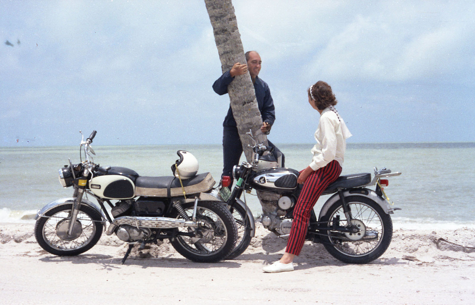
more inspiration was when I scanned some old film negatives of a
motorcycle road trip Jean and I took less than a year after we married,
we did a 3-day ride across the width of Florida, coast to coast, from
the Atlantic Ocean to the Gulf of Mexico, Jean on her first motorcycle, a
Honda Super 90, and me on my first motorcycle, a Yamaha Big Bear
Scrambler. That is one of the best memories of my life.
So in 2014 with all that motorcycle inspiration bouncing around in my brain, I finally decided to get my Motorcycle Endorsement for my driver’s license and start riding again. But getting the Endorsement would be a problem for me as I didn’t have a motorcycle I could use to take a road test.
Robert McCarty, a co-worker from my Florida days and now retired in northern Arizona and a Harley-Davidson Heritage Classic rider, recommended the TEAM Arizona Motorcyclist Training Centers (TeamAz), an organization that offers a Motorcycle Safety Foundation (MSF) training course where you use their motorcycles for training. and when you complete the course successfully you automatically qualify for your motorcycle endorsement without any road test (or written) requirements at the MVD. And since I hadn't ridden a motorcycle in about 37 years, I felt the training course would definitely be beneficial.
In September of 2014 I signed up with TeamAz in Scottsdale, they offered a 2-day, 15-hour class (5 hours classroom, 10 hours on a motorcycle) for $289. I trained on a Honda Rebel 250 motorcycle. The classes were held at the GO AZ Motorcycle dealer, a very short drive from my house.
 |
| Above: Our class had 2 instructors and 12 students. |
 |
| Above: Part of the area where we did our bike riding lessons, black bike in front is the Honda I rode. |
Even in late September the heat was brutal, 10 hours of doing tough exercises in the hot sun nearly did me in, lots of sore muscles from handling the motorcycle. The class required that we wear over-the- ankle boots and the only boots I had were some very old hiking boots that weighed a total of 5 pound for both. It was tough just throwing my leg up over the bike with a 2.5-pound boot.
I hate to admit this but during
the training class, I dumped my training bike once. The accident happened when I was hardly moving, I just lost my
balance and fell on my face. I messed myself up
a little; a bloody nose, split lip, scrapped chin, bruised left thigh,
and bruised right knee.
One
negative thing about the face injuries was I had to have a new photo
taken for my new licenses, so my new licenses showed me with a injured
lip! It had healed up a little by the time I got the new licenses, but
the scab was still very noticeable in the picture. I would show a copy
of this photo but I don't want to sully this write-up.
I
completed the course with no further injuries and got my Motorcycle
Endorsement, and as Freddie Mercury advised fat bottom girls to do, I
was ready to get on a bike and ride!
But in November, something happened that postponed my riding plans, another injury, I injured my left hand at Tempe Town Lake (a kayak fell on my hand from a rack), x-rays showed no broken bones but the hand was swollen, discolored, looked terrible, was painful and took time to heal. The left hand needs to be in good shape when riding a motorcycle as it is the clutch hand.
While my hand was healing I read a book titled France in America
by a guy from England named Gary France who shipped his Harley-Davidson
Road King motorcycle from England to the US in 2010 to make a
21,000-mile road trip through 27 different states. France did a
fantastic job of writing and photographing his road trip. I'm not
normally a big reader but this book was one of the more interesting
books I've read, and was even more inspiration for me to get back into
motorcycle riding.
The Plan
My
hand eventually healed, and after a few months in early 2015 kayaking
in Tempe Town Lake, and a little hiking in South Mountain, I decided in
April to rent a motorcycle and do a one-day ride. I wanted to stick
close to home for this first ride so decided to ride to two very unique
towns next to Scottsdale, Fountain Hills and Cave Creek.
My plan was to rent a motorcycle from AzRide in Scottsdale, then ride to Fountain Hills to see the (1) famous water fountain for which the town is named. After that a stop at the (2) Golden Eagle Hiking Trailhead, then (3) to see where singer/songwriter Jessi Colter lived, then to the (4) Pinnacle Peak Patio, then to (5) Cave Creek where I have a late lunch. After that, back to AzRide and return the motorcycle.
The map below shows the route I scheduled, a round trip of 90 miles on the Google map.
 |
| Above: Map showing the 5 main stops. |
The ride starts
On
Wednesday morning, April 22, 2015, a little after my 74th birthday and
almost 9 years after I retired, I went to the AzRide motorcycle rental
in Scottsdale and rented a black Honda Shadow Spirit 750 motorcycle. I
chose this bike because it fit my needs for a first ride; not too large,
not too small, and based on my research it was a good bike for
beginners, a low seat height, a comfortable riding position, good
stability, and good speed, "fast enough to get you out of trouble but
not fast enough to get you into trouble" as the expression goes.
The basic rental price for the bike was $99, but with insurance, an armored-jacket rental (for protection, ...just in case), taxes, the total charge came to $174 for the day
Even thought this Honda model is not large as road bikes go, I was a tad nervous as I had never ridden a motorcycle this heavy. The Honda 750 weighed around 525 pounds, compared with 300+ pounds for the Honda Rebel 250 I used in my training class, and 360 pounds for the Yamaha Big Bear Scrambler I used to ride in Florida.
Gaylen Brotherson, the AzRide owner, suggested I take a few spins around their area before hitting the open road. So that’s what I did, and riding the Honda 750 did not feel any differently from other motorcycles I have ridden, my nervousness quickly vanished and I felt ready to hit the open road.
Before I left, Gaylen made my photo as he did for all his customers since he posted the photos on his website.
 |
| Above: Photo at AzRide, photo by Galen Brotherson. |
Heading to Fountain Hills
After
the photo at AzRide I stopped by home where Jean also took a photo, I
loaded up my camera gear, water, etc., put on my helmet, gloves and rode
off to the town of Fountain Hills to see the fountain, my first stop
for the day.
 |
| Above: Photo at home, photo by Jean. |
Heading south I picked up Via Linda Blvd., then headed east, past the Scottsdale Mayo Clinic, to Shea Blvd. for the 12-mile ride to Fountain Hills. That part of Shea Blvd. starts out as a nice 3-lane highway, turning into 2-lanes, and then backed to 3-lanes before it gets to Fountain Hills. The road is mostly straight but certainly not dull. The drive in a car from our house to Fountain Hills is impressive with all the natural desert terrain, loads of saguaro cactuses, mountain views, but even more impressive riding a motorcycle.
 |
| Above: View along Shea Blvd. |
After about 20 minutes I turned north off Shea Blvd. onto Saguaro Blvd. and arrived in Fountain Hills, a beautiful town known for its man-made water fountain, once the tallest in the world, but it no longer holds that title.
The fountain was built to attract people to live in Fountain Hills as the location was far from anything else.
Fountain Hills is also known for art and wine festivals, live music, and lots of good places to eat. The town has artwork displayed throughout its downtown. And the scenery is spectacular, outstanding views of the McDowell Mountains and the Four Peaks Mountains.
As shown in the following map, Fountain Hills is somewhat isolated, surrounded by the McDowell Mountains on the west, the Fort McDowell Yavapai Nation on the east, the Salt River Pima Maricopa Indian Community on the south and the McDowell Mountain Regional Park on the north. Note path (arrows) in white from my house to the fountain.
 |
| Above: Map showing Fountain Hills and surrounding areas. |
Fountain Hills was co-developed in 1970 by Robert McCulloch, the same guy that developed Lake Havasu City and reconstructed the London Bridge. McCulloch, also known for the McCulloch chainsaws, was certainly an interesting person, he came to Arizona in 1963.
Speaking of the London Bridge, Walter had earlier proposed a 3-day motorcycle trip to Laughlin, Nevada, where we would also have a chance to ride across the London Bridge. After I get a few solo motorcycle rides under my belt, we will start planning that trip.
Riding to Fountain Hills brought back a flood of memories from earlier visits.
Jean and I have taken relatives to Fountain Hills as a starting point for Jeep and Hummer mountain tours. The last time we were in Fountain Hills was in 2013, a year and a half before this ride when Jean’s sister and brother-in-law came to Arizona for a visit, we spent time around the lake area one day, taking photos of the fountain, etc. We also left from Fountain Hills another day on a Hummer tour to the Four Peaks Wilderness Area.
One time Jean and I went with another couple to an Italian restaurant. The restaurant had indoor and outdoor tables, the outdoor tables faced the lake and was next door to the patio of a wine bar where a friend and her husband played live music, which we could hear from our outdoor table. After the dinner we went over to the wine bar, listened to more of the music and sampled several wines.
Another time Jean and I went to a Limeliters (the 50's group, but with just one original member) concert, a local band I was friends with opened for them. I took photos of the local band that night and later they released an album and used one of my photos for the back of their CD.
One time I did a solo hike on the Fountain Park Trail. After the hike I stopped off at a little coffee place and had an ice-cold coffee with chocolate and whipped cream, plus other stuff that I now forget. The fountain was just going off as I ended the hike so I got to see it in full bloom. After my hike I drove over to Ft. McDowell Casino and played a few hands of blackjack, and watched them set up the outdoor stage and chairs for a Blood, Sweat, and Tears show.
But back to this ride and the famous fountain. I timed my ride so I would arrive at the fountain in time to watch the fountain go off. When the fountain was new it sprayed water 560+ feet high when running all three pumps. Most days now they run only two pumps and the water sprays only about 300+ feet high, it currently goes off every hour on the hour for 15 minutes. Below are a few photos.
 | |
|
 |
|
Above: The fountain. |
 |
| Above: Closer view of the fountain. |
After I watched the fountain, I rode the bike to the Golden Eagle Hiking Trailhead, about a 4-mile ride, but still within Fountain Hills. I wanted to see exactly where the trailhead was as it leads to the start of the Dixie Mine Trail, which I planned to hike later in the year.
The ride through Fountain Hills was very scenic; curves, hills, great mountain views, and nice homes.
 |
| Above: Riding through Fountain Hills. |
I arrived at the trailhead, enjoyed the view of the McDowell Mountains and the desert, took the photo below and rode to my next stop.
 |
| Above: Golden Eagle Hiking Trailhead, with McDowell Mountains in background. |
Heading to Jessi Colter's house
Leaving
the trailhead and Fountain Hills, I rode north on McDowell Mountains
Road which partially runs through the McDowell Mountain Regional Park, a beautiful area where Jean
and I have hiked.
The ride was a nice 12-mile ride and when I reached Rio Verde Drive I headed due west and rode another 6 miles to Jessi Colter's house. Her house is just off Rio Verde Drive on dirt roads. I rode by her house for no special reason, just something to do on this ride since it was on the way.
When
Waylon
Jennings was alive he and Jessi lived in a gated-community in
Chandler, Arizona. But a few years after his death she relocated to
this smaller place in the northern section of Scottsdale. Information on
the Internet
says the house is about 3,400 square feet of living space.
I was surprised that it wasn't in a gated-community, I could have ridden into her driveway, dismounted and knocked on her front door, ...which I didn't of course, being an outlaw she probably has guns.
The map below shows where she now lives.
 |
| Above: Map showing location of Jessi Colter's house in Scottsdale. |
Although I didn’t take a photo of Jessi’s house, I did find one later on the Internet, as shown below.
 |
| Above: Photo of Jessi Colter's house, NOT my photo, taken from the Internet, actually a frame-grab from a YouTube video. |
As a side note, the last time I saw Jessi perform live was in 2013, about a year and a half ago before this ride, at a Concert/Benefit for the Yarnell-19 she was hosting called Out of the Ashes, It was held at The Rock at 32nd Street in Phoenix, an Alice Cooper music center for kids. The Yarnell-19 were the 19 firefighters that lost their lives in the 2013 Yarnell Hill Fire near Yarnell, Arizona.
Heading to Pinnacle Peak Patio
After riding by Jessi’s house I rode over to the Pinnacle Peak Patio on Jomax Road, an old west steak house in the Scottsdale desert, a place where Jean and I have had many meals, her mostly the mesquite grilled steaks and me mostly the mesquite grilled cheeseburgers, both with cowboy beans and a salad, and live music with a dance floor. They also served chicken and ribs. Fantastic food, great Arizona atmosphere, picnic style tables, sawdust on the floor, the servers all wearing western attire, the walls covered with business cards and neckties cut off from customers that made the mistake of wearing them. They also offered hayrides, old-west dress up photos, and there was even a big tank of rattlesnakes in the back. Plus they had an on-site microbrewery that brewed five types of beers, and they served other local brews also, including my favorite, Four Peaks.
Sadly the place was scheduled to close at the end of the month of this ride (April 2015) so I wanted to make one last stop to see it before the buildings are torn down. It’s joining other similar western-theme restaurants that left this area; Greasewood Flat, Rawhide, and Reata Pass Steakhouse. The land has just become too valuable, and luxury houses are being built in their place. News articles says Pinnacle Peak Patio may be relocated, I hope so.
I don’t know how many people could be seated at one time at Pinnacle Peak Patio, but tourist would come up in busloads.
Pinnacle Peak Patio was a great place to take out-of-town guests. One time in 1998 we were there with Jean’s young nephew and niece; G. Gordon Liddy was also there with his son who was a local lawyer and radio talk-show host that I listened to daily as I drove home from work. Jean’s 21-year old niece made the comment about G. Gordon Liddy “Oh, we read about him in our history class.” Jean and I got a laugh from that.
When I arrived at Pinnacle Peak Patio I parked the motorcycle, walked around looking at the old buildings, remembering the many times I'd been there, and took a few photos. I didn’t go inside as they weren’t open.
 |
| Above: Pinnacle Peak Patio. |
 |
| Above: Pinnacle Peak Patio (Pinnacle Peak in background).
|
 |
| Above: Walking back to the bike.
|
 |
| Above: Parking lot of Pinnacle Peak Patio. |
Heading to Cave Creek
After
I left Pinnacle Peak Patio I rode to Pima Rd. which took me to Cave
Creek, a small desert town with cowboy saloons, biker bars, shopping,
gorgeous desert
scenery, ...a very charismatic place. And live music, music is a big
source of Cave Creek entertainment.
Although
about 20 miles from where I live, I did go to Cave Creek a few times
for the live music when I was a workingman. The Cave Creek Coffee
Company (known as C4) was one place I liked. It was a very small place,
especially
for the talent they were able to bring in. Names like Michelle Shocked,
Junior Brown, Tommy Emmanuel, Roy Rogers, etc. But the biggest names I
saw perform there were Chris Smithers one night with Jean, and The
Bastard Sons of Johnny Cash another night with a fellow co-worker.
Their main music venue was outdoors, but they had a smaller indoor music
venue also.
Another place that has live music is the Buffalo Chip Saloon, I saw Jessi Colter perform there many years ago. More recently since I retired I have been to Janey's Coffeehouse & Bodega, and Bryan's Black Mountain Barbecue for live blues music.
I
mention that live music is a
big source of Cave Creek entertainment, I should also say live music AND
motorcycles! Every year they have the Cave Creek Bike Week, hosted by
the Hideaway Grill & Roadhouse, roughly same time frame as the
Arizona Bike Week. Cave Creek is a motorcycle magnet. Lots of biker
bars in Cave Creek.
You will always see motorcycles riding around, any day of the week. I
took the photo below of two Harley-Davidson motorcycles riding by, the
Harley sound is very distinctive, which caught my attention.
 |
| Above: Two Harley-Davidson motorcycles rumbling down the main drag of Cave Creek. |
Below
is a crop of the above photo, notice the riding attire, blue jeans,
T-shirt and no protective gear other than his eye protection, the only
protection required by Arizona law.
 |
| Above: Crop of the previous photo. |
A side note, in 2003 Walter purchased a dirt bike off eBay and picked it up at a pawnshop in Phoenix. Before he and his 12-year old son headed back to California with his bike in his truck, we stopped at the Hideaway Grill in Cave Creek to shoot some pool and check out all the beautiful motorcycles parked there, and there were a bunch.
Another side note, after Sonny Barger
(founding member of the Oakland, California chapter of the Hells Angels
Motorcycle Club) was released from the Federal Correctional Institution
in Phoenix in 1992, he moved to Cave Creek and opened a bike repair shop called Sony Barger's Cave Creek Cycles. He was
also a member of the Cave Creek, Arizona chapter of the Hells Angels Motorcycle
Club. He's still living here in 2015.
The
first time I'd ever heard of Barger was back in the late 60s or early
70s when I read the Hunter S. Thompson book on the Hells Angels.
There
are many art & craft stores in Cave Creek
also. One night, a few years before this ride, while taking in some
live music I went by a little art
studio and saw outside a very large painting of Clayton Moore as the
Lone
Ranger. See following photo.
 |
| Above: Lone Ranger painting. |
Normally I'm not the type to casually stroll into an art studio, but being a long-time fan of Clayton Moore as the Lone Ranger (I still watch his old rerun TV shows) I went inside to meet the artist Ron Wickersham, and view his many other paintings of the Lone Ranger, as well as his other paintings.
Cave Creek is an interesting town to take out-of-town-guests, Jean and I have hosted several relatives there over the years.
But
on this day I just rode up the main drag enjoying the ride and the
view. I finally chose Harold's Corral for lunch. Harold’s has a
western-theme and
specializes in American-style cuisine. They bill themselves as the
"Original Wild West Saloon," they've been there since 1935, that was
years before I was born, even before my parents ever met!
I ate outside on their patio because the weather was so nice, high temperature for the day was about 88F, plus outside was a good place to watch motorcycles ride by, going someplace, coming back from someplace, or just stopping in Cave Creek doing Cave Creek stuff.
Their menu included burgers, steaks, seafood, pasta dishes, barbecue dishes like baby back ribs, etc. I had their bacon-cheeseburger & fries. Delicious!
Harold's has live music throughout the week but none was playing at that time of the day.
Below are a few photos taken at Harold's.
 |
| Above: Outside of Harold's Corral, that's the rental Honda in front. |
 |
| Above: I took a quick peek inside Harold's Corral. |
 |
| Above: The outside patio at Harold's Corral, where I decide to have my lunch. |
 |
| Above: Delicious bacon-cheeseburger and fries. |
 | |
| Above: Saguaros on a hill outside of parking lot at Harold's Corral. |
 |
| Above: Leaving Harold's Corral after lunch. Yep, bad timing on this shot by "Mr. Tripod," I wasn't looking at the camera and saying cheese. |
After the late lunch, I mounted the bike, headed west on Cave Creek Rd., passing again places that have live music; Roadhouse, Buffalo Chip Saloon, Hideaway Grill, Horny Toad, Janey's Coffee & Bodega, Big Earl's Greasy Eats, Bryan's Black Mountain BBQ, Local Jonnys Tavern and Grill, and others.
I also passed the True West Magazine Headquarters, which moved to Cave Creek in 1999. Owner and Editor-In-Chief is Bob Boze Bell is also an amazing artist and singer/drummer in local bands. Bell is also an author and recently wrote the book titled The 66 Kid: Raised on the Mother Road, a book I read being a fan of both Route 66 and Bob Boze Bell.
Heading home
After riding past those places I turned south, and to Cave Creek I said "adios," a phrase Clayton Moore as the Lone Ranger often said on his TV shows. If my bike had been silver I might have said "Hi-Yo Silver." I followed Cave Creek Rd. past Black Mountain to Carefree Highway to Scottsdale Rd., and returned the motorcycle to AzRide by 4:30 pm.
End of this write up.
Miscellaneous Info
The Honda Shadow 750 was a pleasure to ride, low seat height, nice upright seating position, enough power for me, easy handling, shaft drive, 3.7 gallon gas tank, perfect for a leisurely day cruise. I had an excellent day and I'm looking forward to more rides in the months and years to come.
 |
| Above: Photo of Honda Shadow Spirit 750, Just a generic photo from the Internet, NOT the bike I rode. |
Also, AzRide was a good company to rent from. I'll probably rent a few more bikes of this size from AzRide before moving on to larger bikes like the Harley-Davidson and/or Indian.
My total mileage for the day was 93 miles.
I had two cameras for this ride, my 2014 Panasonic Lumix LX100, my 2001 Olympus C-700 UZ, and a tripod.
High resolution photos can be found at my Google Photos album at https://goo.gl/photos/96i7zkMHxr9C2SAW7
https://haroldscorral.com/




.jpg)

